
SUNROAD Outdoor Altimeter
3.2Editor score
Three-system GPS tracking
Seven-day altitude history
Pressure trend charts
Rechargeable LED flashlight
A handheld altimeter helps hikers, campers, drivers, navigators, and field professionals understand elevation and changing weather conditions. The best unit for you depends on whether you prioritize a simple mechanical dial, a compact digital display, GPS navigation, or a combination of altitude, barometer, compass, and thermometer functions.
We compared all 10 products by examining measurement range, resolution, altimeter technology, compass capability, weather functions, power requirements, portability, mounting options, and intended outdoor use. The list includes analog barometric altimeters, digital multifunction instruments, sighting clinometers, and a full-featured handheld GPS navigator.
Each review explains the most useful strengths, practical trade-offs, and the type of user most likely to benefit from that model. Ratings and availability can change, and current prices fluctuate, so check the latest product details before making a final purchasing decision.
3.2Editor score

4.6Editor score

3.4Editor score
As an Amazon Associate we earn from qualifying purchases.
The table below compares all 10 handheld altimeters by core technology, measurement capability, navigation features, and practical carrying considerations. It is intended to make the differences between simple analog tools, digital multifunction meters, sighting clinometers, and a dedicated GPS navigator easier to understand.
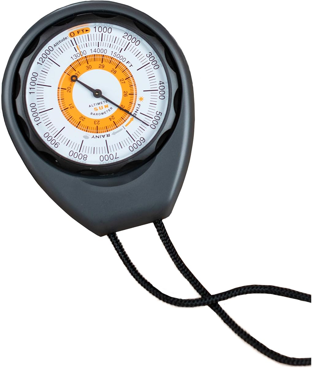


The Sun Company Altimeter 203 is a straightforward analog altimeter and barometer designed for people who want elevation information without charging a battery or navigating a dense digital menu. It carries a 4.3 rating and distinguishes itself through its rugged ABS housing, included lanyard, easy-to-read scale, and weather trend indicator. Its straightforward construction makes it appealing for hikers, backpackers, campers, anglers, and drivers who want a dependable instrument that is ready to use.
We may earn a commission when you buy through this link, at no additional cost to you.
The central benefit is battery-free operation. Rather than relying on electronic pressure sensors, the instrument responds to surrounding barometric pressure through an analog mechanism. The adjustable dial allows the user to compensate for high- or low-pressure systems, which is important because barometric altimeters can otherwise reflect weather-related pressure changes rather than a direct change in elevation. The scale covers elevations from 0 to 15,000 feet, covering many popular hiking and camping environments.
Its limitations are inherent in the analog design. Users must understand how to set the dial correctly, and the instrument cannot record a route, calculate vertical gain, or display a trend graph. It also offers less information than a digital altimeter, compass, thermometer, or GPS navigator. Those compromises are reasonable when the goal is simple, immediate elevation reading rather than comprehensive navigation or data analysis.
Choose the Altimeter 203 if you value simplicity, portability, and freedom from batteries. It is a particularly good fit for a pocket, pack, glove compartment, or emergency kit where an uncomplicated mechanical altimeter is more useful than a complex electronic device. Users who want automatic altitude logs, a compass, or detailed weather trends should choose one of the digital alternatives instead.
The adjustable dial lets users account for changing barometric pressure and maintain a more meaningful altitude reading. Understanding this adjustment is essential for getting consistent results during changing weather conditions.
The protective ABS case and included lanyard suit an instrument intended to travel in packs and vehicles. With no battery requirement, the altimeter remains usable when batteries are depleted or unavailable.
We may earn a commission when you buy through this link, at no additional cost to you.
The BTMETER BT-100WM is a handheld digital anemometer and altimeter that combines elevation measurement with wind, temperature, humidity, dew point, and barometric pressure readings. Its 4.1 rating reflects a broad set of functions for outdoor activities, field work, shooting, sailing, and other applications. The wide altitude range and backlit display make it more versatile than a dedicated mechanical altimeter.
We may earn a commission when you buy through this link, at no additional cost to you.
The instrument provides useful digital flexibility. It measures altitude from 0 to 19,685 feet, displays wind speed in mph, feet per minute, kilometers per hour, meters per second, or knots, and supports altitude in meters or feet and pressure in inHg, hPa, or mbar. A 16-group barometric log allows users to record, compare, and analyze pressure readings alongside temperature, humidity, and height information.
There are trade-offs in complexity and power management. The range of buttons, units, and recorded variables may be excessive for someone seeking a quick elevation reading, and the product relies on batteries. Its stated wind accuracy is plus or minus 5 percent, while temperature accuracy is stated at plus or minus 2 degrees Celsius or Fahrenheit. The tripod hole also makes it more versatile than a pocket-only instrument.
The BT-100WM is best for users who need more than altitude, particularly hikers, hunters, sailors, drone operators, and field technicians who also need wind data. It is a strong choice for campsite weather monitoring and activity planning. Those who only need a simple, battery-free dial should focus on the Sun Company models, while navigation-focused users may prefer a dedicated GPS unit.
Beyond altitude, the BT-100WM measures current and recorded weather variables, including wind, temperature, humidity, dew point, and pressure. This makes it useful when weather conditions affect comfort, safety, or activity quality.
Multiple unit options, minimum, maximum, and average readings, and a five-second backlight improve readability in different conditions. The screen can be used day or night, while the tripod hole supports stationary monitoring.
We may earn a commission when you buy through this link, at no additional cost to you.
The Digital Compass Altimeter Handheld Hiking Thermometer 8 in 1 is a compact digital instrument intended for hikers, campers, mountaineers, and outdoor drivers. It combines altitude, barometric pressure, an electronic compass, temperature, time, and weather information in one device. Its 3.4 rating is the second-lowest among the listed products, but its broad range of functions may appeal to buyers who want more capability from a small handheld tool.
We may earn a commission when you buy through this link, at no additional cost to you.
The advertised altitude span runs from negative 2,300 to 29,500 feet with a resolution of about 3.3 feet. Its barometer covers 300 to 1,100 mbar with a 0.1 mbar resolution, and the compass uses an eight-direction display influenced by the external magnetic field. A five-second electronic backlight, interchangeable Celsius and Fahrenheit readings, a carrying rope, and an English manual support everyday outdoor use.
The principal drawback is that the product listing provides less detail about some functions than the more established digital options. Its lower rating may reflect the overall user experience, and it does not describe GPS positioning, route storage, elevation history, or data logging. The eight-direction display is also less detailed than a 16-point compass, and the 3.3-foot resolution is not intended to match a survey-grade instrument.
This model is most suitable for recreational hikers and campers who want a simple all-purpose outdoor meter at a modest cost. It is less appropriate for serious navigation, expedition-grade surveying, or users who need recorded route data. If the same basic eight-in-one format is needed, compare it carefully with the closely related Digital Altimeter Compass 8 in 1, which has a higher listed rating.
Combining a barometer, altimeter, compass, thermometer, clock, and weather display reduces the number of separate tools needed in a pack. It is convenient for casual outdoor trips where a single handheld instrument is preferred.
The electronic backlight improves display visibility in dim conditions. Carrying rope and a compact format make the unit straightforward to keep accessible during short hikes and camping activities.
We may earn a commission when you buy through this link, at no additional cost to you.
The Digital Altimeter Compass 8 in 1 is a digital hiking instrument with altitude, barometer, compass, thermometer, time, and weather functions. Its 3.9 rating gives it a stronger user reception than the closely related Digital Compass Altimeter 8 in 1. The broad altitude range and clear measurement specifications make it a practical choice for general hikers and campers who want more than a single-purpose altimeter.
We may earn a commission when you buy through this link, at no additional cost to you.
Altitude is measured from negative 2,300 to 29,500 feet with a resolution of approximately 3.3 feet. The barometer spans 300 to 1,100 mbar, allowing the user to monitor pressure variations associated with terrain and weather changes. The electronic compass provides an eight-direction display, and the thermometer covers 14 to 140 degrees Fahrenheit with Celsius and Fahrenheit switching and a stated resolution of 0.1 degree Celsius.
Compared with a dedicated GPS navigator, it lacks position tracking, route storage, topographic mapping, and multi-band satellite positioning. The compass is also limited to eight directions rather than the 16-position compass offered by the SUNROAD unit. For basic route-finding, it offers more convenience than an analog altimeter, but serious travelers should not treat it as a replacement for full navigation equipment.
This altimeter suits recreational hikers, campers, and outdoor workers who want a pocketable combination of elevation, pressure, direction, and temperature. Its clearer stated specifications and higher rating make it the stronger choice between the two closely related eight-in-one devices. For advanced navigation or route recording, choose the Garmin GPSMAP 65s or SUNROAD instead.
The combination of a wide-ranging altimeter and barometer gives users both current elevation and information about pressure trends. It is a practical pairing for hikers monitoring how terrain and changing weather affect conditions.
The compass, thermometer, clock, and backlight add useful functions without requiring several separate devices. Its straightforward specification set makes it easier to compare with other compact hiking instruments.
We may earn a commission when you buy through this link, at no additional cost to you.
The Sun Company AltiLINQ is an analog dashboard altimeter and barometer designed for vehicles as well as outdoor use. It has a 4.2 rating and stands apart through its simple adjustable dial, battery-free operation, and two included hook-and-loop mounting attachments. The product is especially relevant to drivers who travel through mountainous areas or want an elevation gauge readily visible in a car or truck.
We may earn a commission when you buy through this link, at no additional cost to you.
Its 0-to-15,000-foot scale covers a broad range of elevations, while the analog display provides quick reference without navigating menus. As with other barometric altimeters, the user can adjust the dial for high- or low-pressure systems. The weather trend indicator provides an additional indication of incoming pressure conditions, and the unit can be detached quickly for hiking, camping, or backpacking.
The product does not record data, calculate ascent, provide route guidance, or include a compass. Users must also understand and apply the manual pressure adjustment correctly. While the dashboard mounting makes it convenient in a vehicle, the analog face may be less useful for precise digital reference or detailed trend analysis.
AltiLINQ is best for road travelers, overlanders, and outdoor users who want one simple instrument that moves easily between a dashboard and a pocket. It is also a strong option for anyone reducing reliance on batteries. Those who need active navigation or recorded elevation history should consider a digital GPS or multifunction navigator.
Two hook-and-loop attachments make it possible to mount the AltiLINQ in different vehicles and remove it for trail use. This flexibility is more useful than a permanently installed analog gauge.
The weather trend indicator adds context beyond altitude, helping users recognize high- or low-pressure tendencies. The dial remains easy to read at a glance while driving or checking conditions from camp.
We may earn a commission when you buy through this link, at no additional cost to you.
The Handheld Waterproof Clinometer is a sighting altimeter for measuring height and slope rather than atmospheric elevation. It has a 4.5 rating, placing it among the strongest-reviewed products in this group. Designed for backpacking, hiking, exploration, field work, forestry, and other practical tasks, it offers a useful alternative for users who need to estimate the height of a tree, structure, or terrain feature.
We may earn a commission when you buy through this link, at no additional cost to you.
A deflection angle lens enables quick measurements, and the height scales are available in both inches and millimeters. The aluminum alloy construction is described as sturdy, waterproof, and shockproof, while the palm-sized format and thick nylon carry bag support portable field use. Unlike a GPS or barometric altimeter, it works by sighting a target and reading an angle-related measurement.
This distinction matters. A clinometer is ideal when you want to measure the height or slope of something in front of you, but it does not report your elevation above sea level. It also requires line of sight, a stable hold, and some skill in interpreting the scale. It therefore does not replace a barometric altimeter, compass, or navigator for route finding.
The model is well suited to forestry, construction, surveying-related field tasks, trail inspection, and outdoor height estimates. Its high rating, rugged shell, and dual measurement scales are particularly attractive. Choose it for direct target measurement; choose a digital altimeter or GPS navigator when your priority is tracking your own movement and elevation.
The sighting design turns the instrument into a practical height and slope estimator. It is especially useful in forestry, construction, and trail work where direct object measurements are more valuable than electronic elevation logging.
Waterproof, shockproof aluminum construction suits frequent outdoor use. The small format and protective nylon bag make it easier to carry than a full-size surveying instrument.
We may earn a commission when you buy through this link, at no additional cost to you.
The Garmin GPSMAP 65s is a full handheld GPS navigator with a barometric altimeter, electronic compass, topographic mapping, and advanced satellite positioning. It has a 4.6 rating, making it the highest-rated product in the list apart from the narrowly specialized clinometers' close placement. This is the strongest all-around option for hikers, hunters, geocachers, backcountry travelers, and anyone who needs navigation rather than only an elevation number.
We may earn a commission when you buy through this link, at no additional cost to you.
Its 2.6-inch sunlight-readable color display makes routes, waypoints, and map information easier to inspect in the field. Expanded global navigation satellite system support and multi-band technology are intended to improve accuracy in challenging locations such as steep terrain, urban canyons, and forests with dense trees. Routable TopoActive mapping and a federal public land map for the United States add planning value beyond basic point-to-point navigation.
The three-axis compass and barometric altimeter support orientation and elevation in areas where a phone may lack reception or battery endurance. The unit also works with the Garmin Explore website and app for managing tracks, routes, and waypoints, although a compatible smartphone is required. Its button-operated design is more suitable for gloves and deliberate outdoor operation than touch-only use.
This is the recommended handheld altimeter for serious navigation. The trade-off is complexity, size, and a more substantial commitment than a simple digital meter or analog pocket instrument. If navigation maps, route management, and robust positioning are central to your needs, the GPSMAP 65s offers the most complete feature set. For casual elevation checks only, a simpler model will be more convenient.
Expanded GNSS and multi-band technology target accuracy in steep country, urban canyons, and dense forests. These capabilities distinguish the GPSMAP 65s from a basic electronic compass and altimeter.
TopoActive mapping, waypoint management, track and route storage, and a three-axis compass make this a complete outdoor navigation tool. A compatible smartphone can be used with Garmin Explore to organize routes and review field statistics.
We may earn a commission when you buy through this link, at no additional cost to you.
The Carabiner Altimeter Barometer Thermometer is a compact three-function digital instrument for outdoor enthusiasts and drivers. It has a perfect 5.0 rating, although that rating should be considered alongside the smaller size of its feature set. The device combines altitude, barometric pressure, and temperature while adding an integrated carabiner and dashboard mounting options for convenient use in a vehicle or on a backpack.
We may earn a commission when you buy through this link, at no additional cost to you.
Its built-in barometric pressure sensor is advertised as providing a weather forecast for the upcoming 12 to 24 hours. That makes it more than a simple elevation reader, particularly for campers and anglers who want context before changing conditions. The carabiner hook can attach directly to backpack straps, tactical vests, or belts, while the dashboard mount offers a stable location in a vehicle during mountain road trips.
The rugged ABS housing is designed to withstand drops, bumps, and impacts. Nevertheless, this is a focused three-in-one tool rather than a complete navigator. It does not include a compass, GPS coordinates, topographic maps, route tracking, or historical elevation graphs. Buyers seeking those functions should examine the BTMETER, SUNROAD, or Garmin options.
This model is a strong pick for people who want a simple, readily accessible altimeter with barometer and temperature functions. Its clip, protective construction, and dual vehicle-and-pack use make it especially convenient for road trips and lightweight hiking setups. The top rating supports its appeal as an easy-to-carry companion, but feature-oriented users should confirm that three functions meet their needs.
The integrated carabiner attaches the instrument to straps, belts, or a vest without requiring a separate pouch. That accessibility makes it convenient for quick elevation or temperature checks while moving.
A 12-to-24-hour pressure-based forecast adds planning value for camping, fishing, and driving. The device is easy to move between a dashboard and outdoor gear.
We may earn a commission when you buy through this link, at no additional cost to you.
The Pocket Altimeter is a compact, battery-free clinometer designed to measure the height and slope of buildings, bridges, mountains, and other targets. It has a 3.9 rating and offers a distinct combination of professional-style measurement scales, a small aluminum body, and a protective carrying case. It is aimed at architects, travelers, explorers, and field users who need direct angle-based measurements.
We may earn a commission when you buy through this link, at no additional cost to you.
A deflection angle lens supports quick height and slope calculations. The dial combines centimeter and inch graduations, allowing the user to work in the unit system most appropriate for a project. The high-definition azimuth plate and clear dial are designed to make readings easier to interpret. A nylon hand strap reduces the chance of dropping the tool, while a soft thick fabric box with a Velcro flap protects it during storage.
The stated dimensions are 3.01 by 2.13 by 0.55 inches, with a 1.5-inch dial and a weight of 106 grams, or 0.23 pounds. The aluminum alloy body is described as durable, waterproof, shockproof, and sturdy. As with the other sighting clinometers, it requires line of sight and does not report barometric elevation or provide GPS positioning.
The Pocket Altimeter is a compelling choice for field measurements where a full-size instrument would be excessive. It is particularly useful for architecture, travel, exploration, and map-related work that involves estimating heights and slopes. For tracking your own altitude, use a barometric or GPS-based unit instead. The included case and hand strap make this analog model easy to organize and carry.
Centimeter and inch graduations support different measurement conventions. The deflection lens and readable dial help users obtain direct height and slope estimates quickly.
The compact aluminum body is built for portability and described as waterproof and shockproof. A hand strap supports secure handling, while the fabric case protects the instrument between uses.
We may earn a commission when you buy through this link, at no additional cost to you.
The SUNROAD Outdoor Altimeter is a feature-rich GPS and digital altimeter designed for hiking, backpacking, camping, and other outdoor sports. It has a 3.2 rating, the lowest in this group, but its capabilities go well beyond a basic elevation instrument. It combines satellite tracking, altitude history, barometric trends, a 16-position compass, weather functions, a stopwatch, a pedometer, and an LED flashlight.
We may earn a commission when you buy through this link, at no additional cost to you.
GPS, GLONASS, and BeiDou compatibility support position, route, distance, speed, and time functions. The listing describes nine groups of route tracking and return records, along with a claimed positioning error within one meter. Altitude can be shown in meters or feet, and the device records data every 30 minutes for 24-hour and seven-day history curves. Target reminders can also be configured for a selected height or a change of one to 200 meters.
The 16-position compass is more detailed than the eight-direction compasses in the basic multifunction meters. The barometer covers 300 to 1,100 hPa and provides a 24-hour pressure trend chart. A rechargeable battery, included USB charging cable, five-second backlight, and built-in flashlight improve field convenience. However, the 3.2 rating indicates less consistent user satisfaction, and the extensive feature set may be complicated for casual users.
SUNROAD is best for an outdoor enthusiast who wants altitude history and GPS-derived tracking in one device. It is less suitable for someone who wants a simple instrument with immediate readings and minimal controls. Compared with the Garmin GPSMAP 65s, it adds a stopwatch, pedometer, and flashlight but does not offer the same stated mapping and multi-band positioning package.
Automatic 30-minute records create altitude and pressure history curves for 24 hours and seven days. Height targets and change reminders add useful structure for tracking progress during an outing.
Three-system satellite support, route tracking, distance, speed, time, a stopwatch, and a pedometer make this a broader outdoor computer. The built-in flashlight and rechargeable battery are useful additions for extended field use.
We may earn a commission when you buy through this link, at no additional cost to you.
Choosing a handheld altimeter means matching the instrument to the kind of elevation information you need, the environment in which you will use it, and the amount of navigation complexity you want. A pressure-based model, digital multifunction meter, sighting clinometer, and GPS navigator each serve different purposes, so the most important first step is deciding which category fits your activities.
A barometric altimeter estimates elevation from atmospheric pressure, while a sighting clinometer measures the height or slope of a target and a GPS altimeter derives altitude from satellite positioning. Barometric instruments are convenient for monitoring gradual changes in elevation, clinometers are valuable for direct measurements of trees, structures, or terrain, and GPS-based devices are better suited to navigation and route tracking. Choosing the wrong category can make even an accurate instrument useless for your intended task.
The listed ranges vary considerably. The Sun Company models cover 0 to 15,000 feet, the BTMETER reaches 19,685 feet, and the two eight-in-one digital instruments extend from negative 2,300 to 29,500 feet. A range beyond your expected environment offers margin but is not automatically more useful. Resolution also matters: approximately 3.3 feet is suitable for recreational hiking awareness, while direct target-height tools use angle scales for a different level of measurement.
A compass turns an altimeter into a more complete orientation tool. The two eight-in-one products use eight-direction displays, the SUNROAD unit provides a 16-position electronic compass, and the Garmin includes a three-axis compass suited to navigation. A basic analog altimeter gives no direction at all. If you expect to navigate without a phone, prioritize a compass with enough directional detail for your route-finding needs.
Every listed device includes at least some barometric capability, but the depth of that feature varies. The SUNROAD offers 24-hour pressure trends, the BTMETER can log 16 groups of pressure data, the Garmin supports its barometric altimeter within a full navigation platform, and the carabiner model provides a 12-to-24-hour forecast. Think about whether you need a current reading, a trend graph, a forecast, or recorded comparisons.
Battery-free models such as the Sun Company Altimeter 203, AltiLINQ, and Pocket Altimeter are convenient for emergency kits and remote trips because they remain operational without routine charging. Digital devices need batteries or a rechargeable system, though models with automatic shutdown and low-battery reminders can reduce waste. A dedicated GPS or data-heavy navigator is best recharged before a trip rather than relied upon as an emergency-only device.
A small pocket altimeter is easy to carry but may offer less protection or fewer controls than a larger handheld. Garmin prioritizes a rugged 2.6-inch color display and button operation, while the BTMETER includes a tripod hole and a pocket-sized format. The clinometers use compact aluminum bodies, and the carabiner model includes a clip for attaching directly to outdoor gear. Consider where the instrument will live and how it will be carried.
A digital altitude reading does not automatically create a navigable route. The Garmin GPSMAP 65s includes routable TopoActive mapping, federal public land mapping for the United States, and compatibility with Garmin Explore for organizing tracks, routes, and waypoints. The SUNROAD offers GPS-based position and route records, while the smaller eight-in-one devices provide a compass without maps. Only choose a dedicated navigator if navigation is a central requirement.
Analog products provide an immediate visual reading, which can be simpler under time pressure. Digital models add units, backlighting, and menu-based access to data. The Garmin's 2.6-inch color screen is intended for map review, while smaller LCD devices are better for quick numerical checks. Consider glove use, nighttime conditions, display size, and whether a physical compass or button interface will be easier to operate in the field.
Before relying on a barometric altimeter, learn how to adjust it for current barometric pressure using the instructions provided with the product. The Sun Company models use a manual dial, while digital instruments may calculate a reading from an internal pressure sensor. Check the altitude against a known reference when possible, make sure units are set correctly, and allow the instrument to acclimate when moving between dramatically different environments.
For a digital or GPS model, explore the altitude, barometer, compass, history, and logging functions before leaving on a trip. Configure the display units, backlight duration, target reminders, and recording interval as needed. Calibrate or orient the compass away from large metal objects, and use the device in an open area where possible. For a sighting clinometer, hold the instrument steadily, sight the target, and read the appropriate scale after confirming the unit setting.
Keep the instrument within its intended operating conditions and protect it from impact, moisture, and extreme heat even when the product is described as waterproof. Store analog models in their case with the dial protected from prolonged compression. For electronic devices, remove or manage batteries during long storage, recharge the SUNROAD unit before use, and clean the screen and sensors with a soft, dry cloth. Replace a protective case or lanyard if it becomes damaged.
A barometric altimeter estimates elevation from atmospheric pressure, while a GPS altimeter derives altitude from satellite positioning. Barometric devices are often responsive to gradual elevation changes but can be affected by weather systems. GPS devices are especially useful for navigation and route mapping, although their readings can vary with satellite reception and atmospheric conditions.
Analog altimeters can provide useful elevation information when properly set for current barometric pressure. The Sun Company models use an adjustable dial for this purpose. Accuracy also depends on how the instrument is read, whether the user compensates for changing pressure, and whether the intended use requires more precision than a dial can provide.
The Garmin GPSMAP 65s is the strongest choice when hiking also requires maps, satellite navigation, and route management. The SUNROAD is useful for users who want GPS tracking and elevation history. For casual hikers wanting a lightweight combination of elevation, pressure, direction, and temperature, one of the eight-in-one digital meters may be more convenient.
A clinometer measures angle, height, and slope by sighting a target. It is useful for estimating the height of a tree, building, bridge, or section of terrain. It is not designed to report the user's elevation above sea level, so it complements rather than replaces a barometric altimeter or GPS navigator.
A compass is valuable if you need to maintain direction or navigate without a phone. The Garmin and SUNROAD provide more detailed navigation functions, while the two eight-in-one devices offer simpler eight-direction displays. If your activities stay on familiar trails and elevation is your only concern, a dedicated altimeter may be sufficient.
Many models include barometric functions that can provide pressure trends or short-term weather forecasts. The carabiner model advertises a 12-to-24-hour forecast, the SUNROAD provides a 24-hour pressure chart, and the BTMETER can log pressure data. A changing barometer indicates shifting conditions but should not be treated as a complete forecast.
Carrying one can be useful for monitoring elevation, recognizing pressure changes, and supporting navigation in areas without cellular service. For a simple outing, a compact altimeter may be enough. For remote hikes, a GPS navigator with mapping, a barometer, and a compass offers greater value, while an analog model serves as a useful battery-free backup.
Keep it clean, dry, and protected from major impacts, and follow its calibration or pressure-adjustment instructions. Verify units and settings before travel, and compare readings with a known elevation when practical. Electronic models should be fully charged, while analog models should be stored loosely in their protective case rather than compressed.
The Garmin GPSMAP 65s is the leading choice for buyers who need complete handheld navigation alongside a barometric altimeter and compass. The SUNROAD stands out for detailed GPS tracking, historical elevation data, target reminders, and a broad set of outdoor functions. For a lighter and more affordable all-purpose tool, the Digital Compass Altimeter 8 in 1 or Digital Altimeter Compass 8 in 1 combines altitude, pressure, direction, and temperature in a compact format.
Prioritize the type of measurement and the environment in which you will use the instrument. Battery-free Sun Company models are excellent for simple elevation checks and emergency readiness, sighting clinometers excel at measuring visible targets, and dedicated digital navigators suit travelers who need maps and route management. A focused three-function device can work well when convenience and simple attachment to outdoor gear matter most.
Ratings, product details, and prices can change, so check the current listing and specifications before buying. Compare the measurement range, power method, navigation features, and carrying options against the trips you actually expect to take, and ensure the chosen handheld altimeter supports the level of accuracy and guidance your outdoor activities require.